


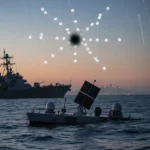
China’s geosynchronous SAR satellite represents a watershed moment in maritime surveillance—and a direct threat to naval concealment strategies that have defined modern warfare for decades. Chinese scientists have successfully demonstrated real-time tracking of a 340-meter Japanese oil tanker using synthetic aperture radar (SAR) mounted on a geosynchronous satellite orbiting at 35,800 kilometers altitude, marking the first time any nation has achieved long-term tracking of a moving object from this orbital height.
Key Takeaways
- China demonstrated real-time tracking of a 340-meter oil tanker using SAR on a geosynchronous satellite at 35,800 km altitude for the first time globally
- Just three geosynchronous SAR satellites can provide continuous 24/7 global ship coverage without needing hundreds or thousands of satellites
- Geosynchronous orbit provides persistent monitoring from a “safe sky abode,” making the system resistant to anti-satellite attacks compared to low-Earth orbit constellations
- The breakthrough potentially eliminates naval stealth in contested waters and reshapes maritime surveillance capabilities
- Traditional full-coverage systems like Starlink-style constellations require vastly more satellites to achieve equivalent persistent surveillance
How the geosynchronous SAR satellite works
The geosynchronous SAR satellite operates from a stationary orbital position where it remains fixed above a single point on Earth’s surface. Unlike low-Earth orbit constellations that require constant replenishment and hundreds of units for redundancy, this system achieves global coverage through elegant simplicity: three satellites evenly spaced in geosynchronous orbit can blanket the entire planet with continuous, all-weather surveillance. SAR technology pierces cloud cover and darkness—conditions that defeat optical sensors—making it effective in any weather condition at any time of day.
The demonstration tracked the Japanese tanker in real time, proving the geosynchronous SAR satellite can monitor moving maritime targets with sufficient resolution and speed to be operationally useful. This capability was previously thought impossible from such extreme altitude; the 35,800-kilometer distance introduces signal delays and atmospheric distortion that engineers assumed would degrade tracking accuracy beyond practical limits.
Implications for US Navy concealment and naval strategy
The geosynchronous SAR satellite fundamentally undermines the concealment advantage that has protected naval forces in contested waters. The US Navy has historically relied on the vast ocean to hide its movements—ships can operate without constant surveillance because no single system could track every vessel simultaneously. This new architecture changes that calculus. With just three satellites providing uninterrupted coverage, every ship becomes visible, trackable, and targetable across all ocean basins.


Traditional alternatives require massive infrastructure investments. A Starlink-style low-Earth orbit constellation providing equivalent persistent coverage would demand hundreds or thousands of satellites, creating a vulnerable, expensive, and politically visible system. The geosynchronous approach achieves the same surveillance reach with a fraction of the satellites, and from an orbital altitude where they are harder to reach with anti-satellite weapons. This asymmetry favors China’s approach and puts US naval strategy on notice.
Why this breaks the old surveillance model
Previous ship-tracking systems relied on either active sensors (radar signals that broadcast their presence) or passive collection from ships and aircraft (which are mobile and limited in range). China’s geosynchronous SAR satellite combines the best of both: persistent coverage from a fixed, high-altitude platform that is difficult to target, with all-weather capability that optical and infrared systems cannot match. The satellite remains in the same orbital slot indefinitely, providing continuous monitoring without the gaps and vulnerabilities that plague constellations.


This represents a genuine technological leap. As one analysis noted in discussing the demonstration, “China may have just changed the rules of modern warfare.” The statement reflects the magnitude of the shift—not an incremental improvement, but a fundamental alteration of what is possible in maritime surveillance. A geosynchronous SAR satellite with sufficient resolution to track individual ships eliminates the ocean’s traditional role as a concealment medium.
What this means for naval forces globally
Every navy operating in contested waters faces the same new reality: persistent surveillance from space with no practical defense. Ships cannot hide, cannot operate undetected, and cannot rely on darkness or weather for concealment. This forces a strategic reckoning for naval planners worldwide. Doctrine that assumes periods of unobserved movement must be rewritten. Force posture that depends on surprise becomes obsolete. And the calculus of naval power shifts toward nations that can operate under constant observation without losing operational effectiveness.
The geosynchronous SAR satellite also raises questions about the sustainability of traditional naval advantage. If every ship is always visible, the advantage accrues to whoever can respond fastest and strike hardest—not to whoever can hide best. This favors forces with superior command-and-control, faster weapons, and better integrated defenses. It also favors the nation that deployed the surveillance system, which possesses the data advantage and can act on information the rest of the world does not have.
Does a geosynchronous SAR satellite really provide true global coverage?
Yes, three evenly spaced geosynchronous satellites can provide continuous coverage of every point on Earth, including the poles. Geosynchronous orbit sits at a fixed altitude of approximately 35,800 kilometers, where orbital period matches Earth’s rotation, allowing the satellite to hover above the same location indefinitely. Three satellites at 120-degree intervals around the equator create overlapping coverage zones that eliminate blind spots. This is far more efficient than low-Earth orbit constellations, which must use hundreds of satellites to achieve redundancy and continuous coverage.


Could the US Navy defend against this surveillance capability?
Defending against a geosynchronous SAR satellite is extremely difficult. The satellite orbits far above the altitude where conventional air defense can reach. Anti-satellite weapons exist, but deploying them would be a dramatic escalation with severe diplomatic consequences. The more practical response involves operational adaptation: changing tactics, increasing deception, developing countermeasures to SAR itself, or accepting that naval operations now occur under constant observation and planning accordingly. None of these options restores the concealment advantage that the geosynchronous SAR satellite eliminates.
Final assessment
China’s geosynchronous SAR satellite represents a genuine breakthrough in space-based surveillance, not merely an incremental improvement in existing systems. The ability to track moving ships in real time from 35,800 kilometers altitude, using only three satellites for global coverage, shifts the balance of maritime power in ways that will take years for naval strategists to fully absorb. The age of naval concealment is ending. What replaces it remains to be written, but every navy on Earth is now operating in a world where the ocean no longer hides what moves across it.
This article was written with AI assistance and editorially reviewed.
Source: TechRadar


