


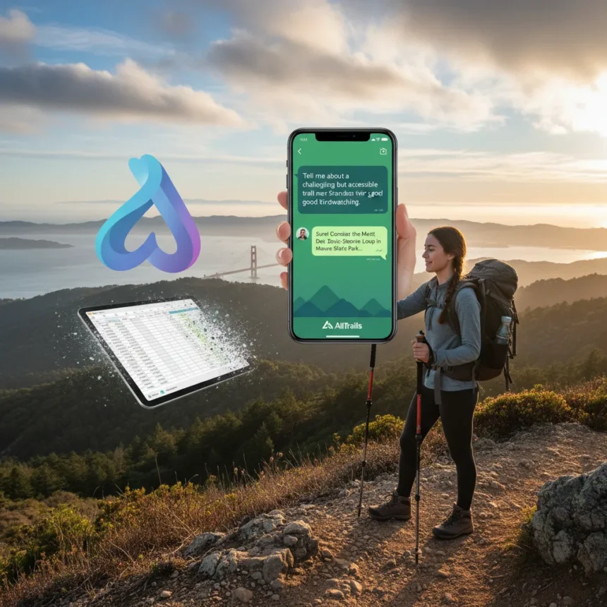
AllTrails Claude AI hike planning marks a significant shift in how millions of outdoor enthusiasts discover and plan trails. The hiking app, which serves over 50 million users and indexes 400,000+ trails, has partnered with Anthropic to embed Claude into its platform, launching the conversational feature in April 2026. Instead of clicking through filters and maps, users can now ask natural questions—”Show me dog-friendly trails under 5 miles with minimal elevation gain”—and Claude handles the reasoning across AllTrails’ proprietary database.
Key Takeaways
- AllTrails partnered with Anthropic to integrate Claude AI for conversational trail discovery and itinerary planning.
- The feature launched in April 2026, available globally on iOS and Android apps at no extra cost for AllTrails users.
- Claude handles complex queries about difficulty, elevation, weather, pet policies, and trail conditions in natural language.
- AllTrails+ subscribers ($35.99/year) unlock premium offline maps alongside the new AI planning tools.
- The integration represents one of the first major outdoor apps adopting frontier AI for practical consumer trail planning.
Why AllTrails Chose Claude for Trail Planning
AllTrails selected Claude specifically for its safety, reliability, and reasoning strength in real-world planning tasks. Unlike generic chatbots trained on internet text, Claude can ground recommendations in AllTrails’ curated trail data and apply multi-step reasoning—weighing weather forecasts, elevation profiles, user fitness levels, and pet restrictions simultaneously. This matters because a bad trail recommendation isn’t just inconvenient; it can strand a family on an unexpectedly steep climb or send a dog owner down a trail where pets are prohibited. Anthropic’s focus on AI safety aligned with AllTrails’ need for trustworthy recommendations at scale.
The partnership also reflects a broader shift in outdoor tech. Apps like Gaia GPS and Strava offer detailed mapping and social features, but they lack conversational AI anchored to proprietary trail data. AllTrails’ advantage lies in its scale—400,000+ trails with user reviews, photos, difficulty ratings, and seasonal updates—combined with Claude‘s ability to synthesize that information into natural-language responses. A user can ask follow-up questions (“What about this weekend’s weather?”) and Claude maintains context across the conversation, refining recommendations without forcing users back to square one.
What AllTrails Claude AI Hike Planning Actually Does
The feature handles the friction points that make trail planning tedious. Instead of browsing categories, a user types or speaks a query: “I want a moderate hike near Denver, 6 to 8 miles, with water access, suitable for kids.” Claude parses difficulty level, distance, location, terrain features, and audience suitability, then returns specific trail suggestions with reasoning. If a user asks about weather, Claude can factor seasonal conditions into recommendations. If they mention a dog, the AI identifies pet-friendly trails and notes any restrictions (leash requirements, seasonal closures).


The conversational layer also handles itinerary building. Users can ask Claude to string together multiple trails into a weekend trip, suggest parking logistics, or recommend nearby accommodations. This transforms AllTrails from a lookup tool into a planning assistant that understands context and constraints. The feature is free for all AllTrails users via a standard app update; AllTrails+ subscribers at $35.99 per year gain access to premium offline maps and detailed topographic data, which Claude can reference for more granular recommendations.
AllTrails Claude AI Hike Planning vs. Static Search Tools
Traditional trail apps rely on filters and tags. You select difficulty, distance, and elevation gain, then scroll results. This works if you know exactly what you want, but it breaks down with nuanced requests. Suppose you’re visiting a new region with unfamiliar trails and you want something “challenging but not technical, good for photography, with a summit view and fewer crowds.” A filter-based system forces you to make trade-offs and guess. Claude understands the interplay between those constraints and can surface trails that balance them, explaining why each suggestion fits.


The AI also learns from conversation. If a user dismisses a suggestion because it’s too crowded, Claude adjusts its recommendations without the user re-entering their entire criteria. This adaptive behavior is impossible in static search interfaces. Competitors could build similar features, but doing so requires either licensing a frontier AI model (which AllTrails has done with Claude) or training a custom model on trail data—a costly, ongoing effort that smaller apps cannot justify. AllTrails’ early adoption gives it a moat, at least until competitors catch up.
Potential Limitations and What Users Should Know
AllTrails Claude AI hike planning is not magic. Claude’s recommendations depend on data quality in AllTrails’ database. If a trail is outdated, poorly reviewed, or missing key details, Claude may suggest it anyway. Users should treat AI recommendations as a starting point, not gospel. Checking recent user reviews, weather forecasts, and trail condition reports before departure remains essential. The feature also requires an internet connection for real-time queries, though AllTrails+ users can download offline maps to mitigate this.
The “less painful” framing in marketing materials is promotional language without user testing data. AllTrails has not published results from beta testing or A/B comparisons showing that Claude planning is actually faster or more satisfying than traditional search. Early adopters will be testing this claim themselves. That said, the feature addresses a genuine pain point—planning hikes across hundreds of thousands of options is genuinely tedious—and Claude’s conversational interface is a sensible solution.
Is AllTrails Claude AI hike planning free?
Yes. The feature is free for all AllTrails users via app update. AllTrails+ subscribers ($35.99/year) unlock premium offline maps and topographic data, which Claude can use for more detailed recommendations, but the AI planning feature itself costs nothing extra.


Can I use AllTrails Claude AI hike planning offline?
The conversational AI feature requires an internet connection to function. However, AllTrails+ subscribers can download offline maps and trail data, which they can reference manually. Future updates may enable offline Claude queries, but the current version does not support this.
How does AllTrails Claude AI hike planning compare to Gaia GPS or Strava?
Gaia GPS and Strava excel at detailed mapping and social features, but neither offers conversational AI planning anchored to trail data. AllTrails’ integration with Claude is a differentiation—it lets users ask natural questions rather than clicking through filters. Gaia and Strava could build similar features by partnering with an AI provider, but AllTrails is the first major hiking app to do so at scale.
AllTrails Claude AI hike planning is a practical example of frontier AI solving a real consumer problem. It will not reshape hiking, but it will save time for millions of users planning weekend trips. The feature is available now, free, and worth testing if you use AllTrails already. For casual hikers, it cuts planning time significantly. For serious outdoors enthusiasts, it remains a convenience layer—still check recent reviews, weather, and trail conditions before heading out.
Edited by the All Things Geek team.
Source: T3