


Celestial navigation GPS backup technology may sound like Cold War nostalgia, but it represents a genuinely resilient alternative to satellite-dependent positioning systems. If a coronal mass ejection or electromagnetic pulse knocked out GPS infrastructure, military and civilian aircraft would lose the primary navigation method they have relied on for decades. Yet a decades-old electromechanical system aboard the B-52 bomber demonstrates that the stars remain a viable fallback.
Key Takeaways
- The B-52’s Astro Compass automatically locks onto stars and outputs heading accurate to a tenth of a degree.
- Celestial navigation requires no satellites, radio broadcasts, or digital infrastructure—only clear skies and star charts.
- An electromechanical Angle Computer solved navigational triangles by physically modeling the celestial sphere.
- Similar star trackers were deployed on the SR-71, RC-135, B-58 bomber, and P-3 Orion aircraft.
- A coronal mass ejection strong enough to disable GPS could leave celestial navigation as one of the few viable positioning methods.
How Celestial Navigation Works in Practice
Celestial navigation operates on a principle humans understood centuries before GPS existed: observe the position of a celestial body—the sun, moon, or a star—and calculate your location from that observation. The navigator sights on the object, measures its altitude and azimuth, then compares those angles to reference data showing where the sun or star should appear at different times and locations. Done correctly, this method is accurate, impossible to jam, and completely independent of broadcast infrastructure.
The catch is complexity. Manual celestial navigation demands skill, time, and clear skies. A navigator must know which stars to target, calculate the local hour angle, work through trigonometric intercept plotting, and account for drift and wind. On a fast-moving aircraft, the window to sight a star is brief, and human error compounds quickly. This is why, despite celestial navigation’s theoretical resilience, it fell out of favor once GPS became available. Why spend five minutes on manual calculations when a receiver delivers position in seconds?
The military answered that question differently. If GPS could be disrupted, the ability to navigate by stars without human intervention would be invaluable. That logic drove the development of an automated star-tracking system for the B-52 in the early 1960s.


The B-52’s Angle Computer: Mechanical Elegance
When engineers set out to automate celestial navigation aboard the B-52, they faced a constraint that shaped the entire design: digital computers were not suitable for the job at the time. Instead, they built an electromechanical analog computer called the Angle Computer, which physically modeled the celestial sphere to solve navigational triangles. This was not a gyroscope or inertial measurement unit, despite surface resemblance. It was a purpose-built mechanical calculator that converted star positions into navigation data.
The heart of the system is a half-sphere with a radius of 2 5/8 inches, representing the celestial sphere itself. A star pointer is mechanically positioned on the surface of this sphere using the star’s declination and local hour angle, adjusted by the aircraft’s latitude. As the pointer moves, it drives a readout mechanism that translates the star’s position into azimuth and altitude—the angles needed to determine heading and calculate position. Those angles are sent electrically through synchros (synchronous motors) to the navigation system via wires.


The elegance of this design is that it requires no spinning components, no gyroscopes, and no digital logic. It is pure mechanical translation between coordinate systems. An electromechanical system like this can function in electromagnetic environments that would disable digital electronics. A nuclear burst or severe solar storm that disabled semiconductors would leave the Angle Computer intact.
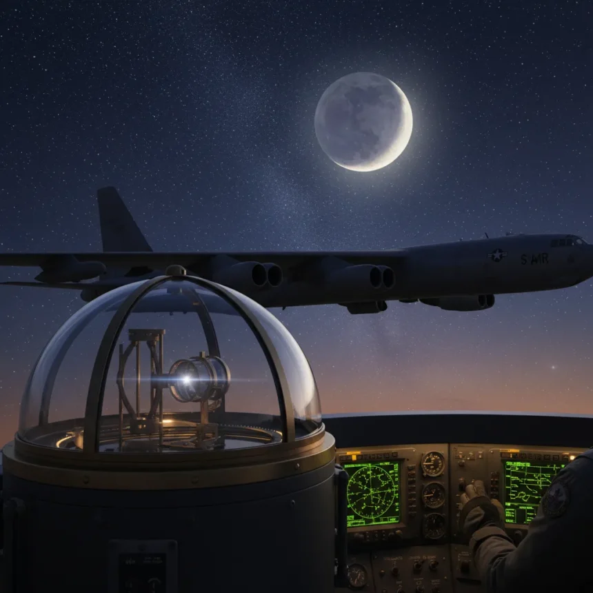
Astro Compass: Automatic Star Acquisition and Lock
The Angle Computer was part of a larger system called the Astro Compass, which included an automatic star-tracking mechanism. The star tracker does not require a human to manually aim at a target star. Instead, it starts with an approximate sky position and performs a spiral search pattern covering ±4° in bearing and ±2.5° in altitude—a search area roughly eight times the width of the moon. Once a star is found, a photomultiplier tube and slotted disk create a feedback loop that keeps the system locked onto the star.
The lock mechanism works by detecting whether the star is centered on the sensor. If the star drifts off-center, the output from the slotted disk peaks when the slot aligns with the star. This produces an error signal whose phase indicates the direction to the star. The signal is demodulated into X and Y corrections that drive the sensor back toward the star, maintaining lock automatically. Once locked, the system outputs a heading accurate to a tenth of a degree.
Early B-52 aircraft used a human sextant through a bubble in the top of the fuselage. This manual method was replaced on E and F models in the late 1960s by the automatic astro tracker and its Angle Computer. The shift from human operator to electromechanical automation eliminated the need for a trained celestial navigator aboard the aircraft.


Why Celestial Navigation Matters If GPS Fails
A coronal mass ejection strong enough to disable GPS satellites or ground infrastructure would leave modern aircraft without their primary navigation method. Inertial navigation systems could provide a fallback, but they drift over time and must be calibrated or updated by external references. Celestial navigation offers something different: a direct fix from the sky that does not depend on any ground station, satellite constellation, or radio signal.
The B-52’s system was designed to work in a world where GPS did not exist. That same independence makes it relevant in a world where GPS might suddenly disappear. Unlike digital systems, an electromechanical Angle Computer cannot be fried by electromagnetic radiation. Unlike inertial navigation, celestial navigation does not accumulate error over time—each star observation is a fresh position fix. Unlike radio beacons, the stars require no infrastructure to maintain.
Other military aircraft also carried similar star trackers. The SR-71, RC-135, B-58 bomber, and P-3 Orion all used comparable systems. These were not experimental oddities—they were operational aircraft that relied on celestial navigation as a core capability during the Cold War.
The Modern Resilience Question
Today’s aviation infrastructure is almost entirely dependent on GPS and digital systems. Commercial aircraft, military transport, and civilian navigation all assume satellite positioning will be available. A sustained GPS outage lasting days or weeks would create a navigation crisis. Celestial navigation cannot replace GPS for high-volume commercial traffic, but it could sustain critical military operations and emergency flights when nothing else works.
The irony is that the technology already exists. The B-52 fleet still flies, and some of those aircraft retain their Astro Compass systems as backup navigation. No new invention is required—only the recognition that old technology, properly maintained, can provide resilience that modern systems cannot match. In an age of space weather threats and electromagnetic vulnerabilities, that may be the most important lesson the B-52’s star tracker has to teach.
Can celestial navigation work during daylight?
Celestial navigation requires visible stars or the sun. The sun can be used for daytime navigation, but it provides less precise position data than star observations. Night operations are ideal because multiple bright stars can be observed simultaneously, allowing the navigator to cross-reference and verify position.
How accurate is the B-52’s Astro Compass compared to GPS?
The Astro Compass outputs heading accurate to a tenth of a degree, which is suitable for navigation but not as precise as modern GPS receivers in ideal conditions. However, GPS can be jammed or disabled, while celestial navigation cannot. The Angle Computer trades some accuracy for absolute resilience.
Would celestial navigation work after a nuclear electromagnetic pulse?
Celestial navigation would likely work because the Angle Computer contains no semiconductor electronics to be damaged by electromagnetic radiation. Digital systems would fail, but the electromechanical mechanism would remain functional as long as the optical components and mechanical linkages survived the physical shock.
The B-52’s star-tracking system is a reminder that resilience sometimes means embracing older, simpler technology. In a world increasingly dependent on satellites and digital infrastructure, the ability to navigate by the stars—without computers, without broadcasts, without any ground support—remains a capability worth preserving.
Edited by the All Things Geek team.
Source: TechRadar